|
 |
Mouse River Facts
 |
|
|
|
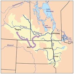
| Attribution: This is a map of the Red River of the North drainage basin, with the Souris River highlighted. Karl Musser, created it based on USGS and [[:en:Digital Chart of the Wo). |
|
About the Mouse
The Mouse River (known as the Souris River in Canada) has its headwaters located approximately 50 miles southwest of Regina, Saskatchewan, not too far from the city of Weyburn. The Mouse River flows for some 435 miles, crossing into the United States near Sherwood, North Dakota. From here, the river runs through or near the communities of Mouse River Park, Burlington, Minot, Sawyer, Velva, Towner and Westhope. After Westhope, the river continues north until it reaches the Assiniboine River in Canada, a tributary to the Red River.
A brief look at the history of floods along the Mouse River can be found here.
Click here for an indepth look at the 2011 Mouse River Flood.
|
|
|